The first project that I set for myself on the web was a series of photographs to be made along Interstate 66, which runs from an interchange with I-81 in the vicinity of Strasburg, Va. and follows an eastbound track through the exurbs and suburbs into the West End of Washington. (Wow, it looks like I didn’t preserve that project online in the course of my ISP migrations.) In 1997 and therebouts, I took hard photos, printed from film, and scanned them.
 Most of what I have in the shoebox is so-so, but there are a few snaps that are worth rescanning and uploading. I like the contrast between the sharp focus and the motion blur in this picture from the neighborhood of Thorofare Gap in Prince William County.

 Two images from the East Falls Church Metro station. Notice that the lead car of the train is one of the old cars with a non-illuminated line designation sign; rather, it’s one of the old school cars sporting a cardboard sign in the window.
 I was impressed that there are sections of the Martha Custis Trail that run right next to 66, with nothing but a wire fence separating bikes and cars. I’m still impressed.
 I-66’s final interchange in the District was originally built to tie the expressway into the (unbuilt) North Leg of the Inner Loop Freeway and (unbuilt) I-266. The ramp was demolished and the interchange reconfigured a few years after I took the picture.
 The outbound access to I-66 hasn’t changed much in 17 years. Drivers leaving the Kennedy Center still have an awkward left turn across Virginia Avenue, N.W. into a rump section of I St., N.W. to get to the onramp.
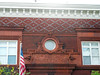 One of the highlights of Kent Boese’s walking tour of the Park View neighborhood was the fancy architectural detailing on the 10th Precinct Police Station. The building was built in 1901; the architects were A. B. Mullet & Co.